Wednesday, September 10, 2014

Glacier NP, post dos


Here is a summary of our time in Glacier!

We hiked every day we were in Glacier, below is a summary of each of our day hikes. Each lake won its own award in accordance to our very complicated and official rating system.

Day 1- St Mary and Virginia Falls. So day 1 didn't really include a hike to a lake, but it wins for the most crowded day! Woot! It was the 4th of July, which is one of the busiest days in all national parks. We hiked to see St Mary falls, which was a quick 2 miles. Lots of families with kiddos there having some lunch and whatnot. We carried on another few miles to a nice view of Virginia falls and stopped there for a lovely snack break. Then we continued all the way to the base of the falls and the "splash zone"! We walked out to the base where the freezing cold spray soaked us! It felt awesome to cool off, especially while hiking in the hot sun! Then we drove west on the Going to the Sun Road. WOW. Beautiful! So much to look at! Mountains and beautiful cascading falls everywhere. Without a doubt the most scenic road I've driven on. And that's saying something considering I've been on the entire Alaska Highway (twice!) and through the Canadian Rockies, American Rockies and the Sierras. We took the road all the way to the other end and stopped at Lake McDonald to dip our toes in the lake. We looked around the lodge at Lake McDonald, which reminded me a bit of the Ahwahnee hotel in Yosemite: old, historic, gorgeous and rustic. Then we headed back east on the Going to the Sun Road and saw everything that was behind us when we were driving west! Taken again by the beauty of it all! We headed back to camp and made some dinner then watched fireworks all around us. Later in the night the last hurrah of fireworks were visible from our tent! It was fun to watch them.

St Mary falls

Virginia falls. Look at how small Verde, my backpack, is! There was nothing really in her in this pic, she was level with the top of my head on the JMT!

Splash zone of Virginia falls! Brrrr, it was super windy and the spray was SO cold!

Going to the Sun Road

The last section of road to be cleared before the road can open is the area of this snow drift, at times it can be 60 feet tall! Here it's melted a bit and is only about 10 feet tall.

Trunk lunch on the Going to the Sun Road, talk about lunch with a view!

Dipping our toes in Lake McDonald

Lake McDonald

Adventure is Out There!
The beautiful cascading Bird Woman Falls


Day 2- Iceberg Lake: Most Adventurous- Iceberg Lake would turn out to be the most adventurous hike of our week spent in Glacier. The trail was mostly exposed which allowed for uninterrupted views of the surrounding mountains! Just beautiful! After a few miles we came to Ptarmigan Falls, which was a pretty waterfall with a super narrow chute that the water funnels through before cascading over the edge. The bridge to cross the falls was partially down; part of the bridge had washed out and the rest of the trail to Iceberg Lake was “closed”... whelp, we went ahead and crossed the bridge anyways. There was only a gap a few feet wide to get onto the bridge. Daveed went first, then took my pack for me. We figured if the bridge would hold him, it would hold me. We crossed with no issues and continued on. About 2 miles from the lake small snowfields started to cover parts of the trail. We crossed them with no issues, I was glad to have my trekking poles for balance. Then about a mile from the lake, the trail was covered by a snow field that would end up taking us all the way to the lake. We lost the trail a couple times, Daveed broke through a thin part of snow and post holed up to his knee which resulted in his shoes getting wet. I followed Daveed up and over a ridge and we came to a small lake, with icebergs floating in it. This must be it! Iceberg Lake!...but it’s so small...I thought it would be bigger...and it’s not butted up against the wall of the mountains...and there’s no glacier running into it like in the pictures… Turns out it was not Iceberg Lake! We continued up and over another ridge, finally finding a trail in the snow. When we crested the ridge, there it was! The real Iceberg Lake! It was almost completely frozen over, only the first few feet off the shoreline was water. The wind off the lake was cold so we put on our layers, had a great backpacker’s lunch and took in the scenery. We rested for an hour or so, then after drying out our socks and shoes as best we could, we packed up and headed back. The hike back was rather uneventful, we were able to find the trail back across the snow with no problems. The beautiful scenery surrounded us again as we hiked back!! When we got back to the car there was a crowd of people around a pair of binoculars that a ranger had set up--- mountain goats! Up on the mountains above the parking area there were 3 or 4 white mountain goats hanging out. That was neat to see.


So, Iceberg Lake wins for most adventurous hike. The snow the last mile or more of the trail slowed us down a lot and made finding the trail difficult. I will say that it was unexpected but fun to hike in snow in July! The backs of Daveed's legs got sunburned from the glare off the snow :)


Snow!

Iceberg Lake

Too cold for anything more than a toe dip!


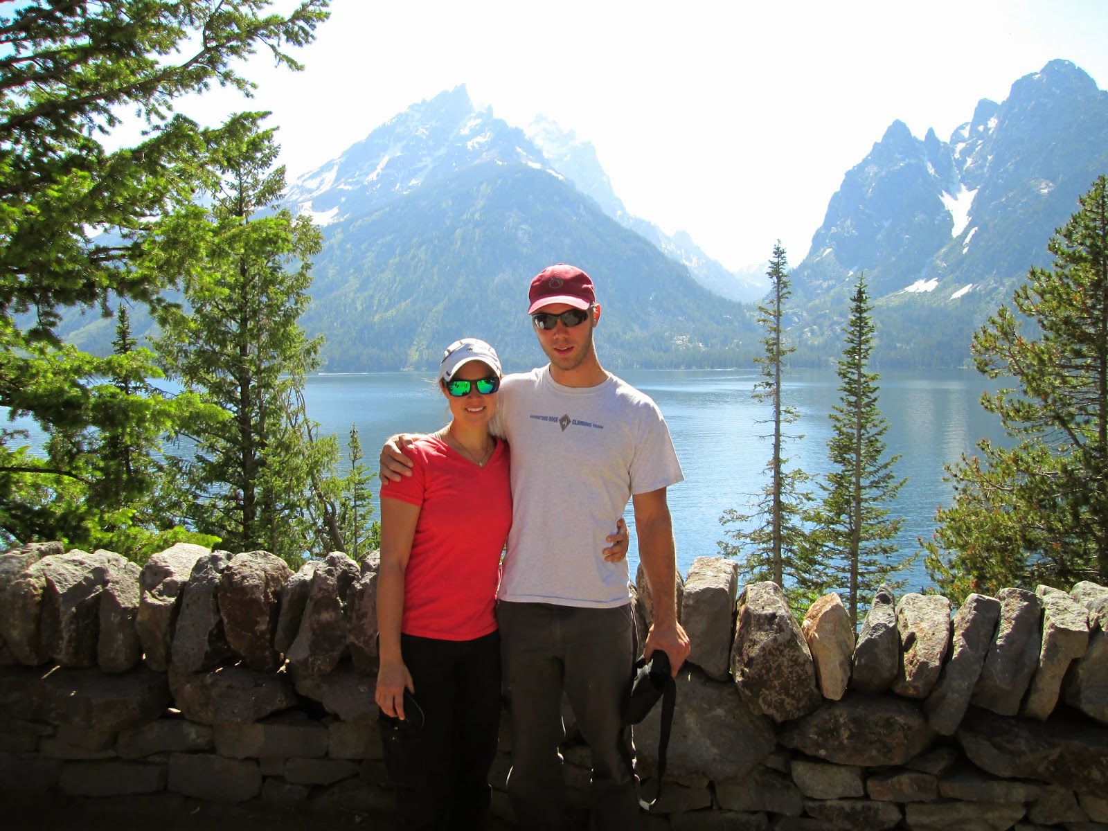
Day 3- Wild Goose Island- Most Scenic. Wild Goose Island wasn’t actually a hike, you can see it off the Going to the Sun road. I have been looking at pictures of Wild Goose Island for nearly 20 years. There is a picture of it in every naturescape calendar I buy, every year. Well, I finally got to see it with my own peepers!!! The road where Wild Goose Island is located is under construction, so the look out/trail to go see it is closed. Well….I didn’t drive 2000 miles to Glacier NP to not see it...so… after some recon, when no other cars were around, I pulled over in a no parking area and we sprinted up the road to the lookout. I had just snapped a couple pictures when Daveed said, ummmm, there’s a ranger… GAH! Busted! Where did he come from!? Was he hiding in the bushes or something?! From the time we parked the car to when the ranger appeared, no more than 2 minutes had passed: 1 minute to sprint to the lookout, 1 minute to take 2 pictures on the camera and 2 pictures on my phone. Crap. So the ranger walks up and I’m expecting us to be in big trouble and he says “would you like me to take your picture?”. I say “ummm, yes please?”, then he says “great, cuz I’m about to kick you out of your parking spot”. Word. He took a couple pictures of us, then escorted us merrily back to our car. He reminded us that the area was closed due to construction and that “monkey see, monkey do happens pretty quickly around here, we don’t want other people to think they can park where it is clearly marked no parking”. Right. Sorry about that. And the lookout/access point is also marked with a “No Public Access” sign and is closed… Right. Sorry about that... So although my viewing of it was rushed, I’m so glad I got to see Wild Goose Island!! It’s no wonder it’s the most photographed spot in the park- it’s beautiful!


We took the rest of the day to relax, shower, do some laundry and eat our first piece of huckleberry pie at the Two Sisters Cafe. I thought about going swimming in the campground’s super clean pool, but ended up getting lost in the guidebook and maps, picking out some more hikes while Daveed took a nap.


Wild Goose Island. YESSS!!

Thank you nice Ranger Man for taking our photo!


Day 4- Otokomi Lake- Best Weather- Otokomi Lake wins for best weather, it was mostly overcast and cooler on this hike- which was a relief as my skin had already had enough of the sun already. I have been diligent with putting on sunscreen as the exposure and slightly higher elevation seems to make the sun stronger. My shoulders are super dark and crispy! I’ve been hiking with a baseball hat on to help keep the sun off my face, which has worked nicely. ¾ of the trail was in the woods, passing many small creeks and meadows with the prettiest wildflowers! There were also a lot of skeeters in the woods... A couple in front of us on the trail saw a small momma black bear and a cub, they made some noise and encouraged the bears to be on their way, then double backed to find us as they didn’t want to hike through that section by themselves :) They had been told that a grizzly was in the campsite at the trailhead that morning, so they were already a little spooked. We saw all the hubub with the grizzly as we pulled into the parking lot: many rangers, flashing lights etc etc. Only one thing could cause such a fuss: a grizzly. Anyways, we hiked with them through the bear section, making plenty of noise, but their earlier encounter had already scared the bears off, there was nothing to see. Daveed was disappointed as he would have liked to see the bears, but they were gone.


After 5 miles of mostly wooded trail, we reached the exposed mountainside where we crossed a few small snow fields, then dropped into the valley where the lake was. The outlet stream of the lake had trout! They were just hanging out in the current, so perfect looking! We got to the lake and met the same couple again, took each other’s picutres and then they headed back. We ate lunch on the tiny shore and enjoyed the views. The lake was calm and provided an awesome reflection of the mountains behind it! We bundled up as the breeze off the partially frozen lake was really cold, and then relaxed for a while and rested. The hike back wold have been completely uneventful but… as I was rock hopping across a creek, both of the rocks each of my feet were on dumped me off at the same exact time and into the creek went my feet. The water went up and over the tops of my boots completely soaking my socks and shoes. Oh boy...so I hiked on a couple more miles with super wet feet, hoping the blister on my right foot wouldn’t get any worse and that no new blisters would form. We stopped to rest on a log bridge where I took off my socks and shoes and tried to dry them out. We realized after 15 minutes that this wasn’t going any where, thankfully Daveed had packed a couple extra pairs of socks, so I wore his socks and we hiked the rest of the way out. My socks finally dried overnight and it took my boots 2 days to dry out, even after leaving them in the sun for 4 hours! Gortex is great except when you get the inside of your boots wet!


Otokomi Lake wins for best weather as it was probably only 70 when it was overcast, the sun makes all the difference when at higher elevation! There was also a nice cool breeze the entire day.


Otokomi Lake

Lunch on the shore


Day 5- Trail of the Cedars and Avalanche Lake- Most Beautiful Backdrop- Avalanche Lakes wins for most beautiful backdrop as the half dozen or so mountain streams flowing into it make for the most beautiful scenery! The color of the lake was a pretty turquoise, as are most of the glacial lakes. The silt in the water from the glaciers refracts only blue light, so that’s why all the glacial lakes have such a bright blue/green color.


We were tired from our previous days hikes, so we decided to take it easy. It was really hot and Daveed wanted to go swimming in Lake McDonald, so we headed west on the Going to the Sun road and stopped to hike Trail of the Cedars and Avalanche Lake. The guidebook warns that this is the most popular and crowded trail in the park with more “bear bell bedecked tourists” than you can shake a stick at. Well, it was right. It was super crowded and most of the children had bear bells tied to their shoes! The easy 5 mile trail only gains 500 ft of elevation and the view of the lake at the end of the trail is incredible. The trail is incredibly wide too, making it family friendly for everyone to string out and hold hands. I swear the trail is 5 or 6 people wide at some points! We had a very enjoyable stroll to and from the lake as we didn’t carry anything except a 1 L camelback. I even wore my trail running shoes, partly because my hiking boots were still wet inside but also because I wanted something lighter on my feet. We flew up the trail, feeling light as feathers! The Trail of the Cedars was a short boardwalk through the woods with pretty greenery and lots of big cedar trees. After hiking it was time to swim, it was nearly 90 degreez and sunny- lake time! We drove the short distance to Lake McDonald and “swam” up to our knees… the water was a bit chilly to really swim in but it did the trick- we cooled off and felt refreshed!


On our way back to camp driving east on the Going to the Sun road, we stopped at Logan Pass to eat a snack and as we pulled into the parking lot, several big horn sheep came up and over a ridge, walked into the lot and right up to our car! It was a bit scary as they have really big horns! We talked to a ranger who said they have been having a lot of issues with the sheep coming into the parking lot looking for salty foods. These particular sheep found some almonds on the ground and were headbutting each other over them. Someone’s car got dented before the ranger could shoo them away. She picked up the almonds and put them in the garbage… A good reminder to everyone around to be mindful about food prep and eating- clean up well and do not eat food around wildlifes!


So, Avalanche Lake wins for most beautiful backdrop, just look at all those pretty cascading mountain streams!


Avalanche Lake


Lake McDonald

Sheeps!

Little Chief Mountain


Day 6- Cracker Lake- Best Color! Cracker Lake wins the prize for the best color, drop dead gorgeous turquoise! We had seen many pretty lakes by this time, but Cracker Lake made us both say “oh wow!” when we first saw it! And it saves its view until the very last moment: you don’t get to see the lake unitl you come up and over several ridges that seem like they’d give you a view, but don’t. You finally get to see the lake when the trail comes up and over the final ridge and comes along the side of the lake. Wow. The color was just stunning! The hike to Cracker Lake was the longest we did, and we did it on our last day in Glacier, starting at noon… We spent some extra time in camp to repack the car to get it ready to depart early the next morning to head to Portland.  The trail was just over 12 miles. The first 3 or 4 miles are in the woods, with lots of skeeters and flies...the first couple miles of trail are shared with horses, so all the manure dodging and flies got really old really fast. But, once you clear horse country, the trail cleans up and crosses a couple of big creeks. We had to rock hop to get to the log bridges, which after my boots got soaked, I was a bit nervous about, but had no issues :) Feet were nice and dry apart from my own sweat :) When the trail emerges from the woods you are rewarded with amazing views of the surrounding mountians. The tallest vertical alpine wall in the lower 48 borders Cracker Lake, someone said it’s around 9000 sheer vertical feet!


We took a nice long break at the lake and enjoyed some lunch along with watching some curious but not rude ground squirrels. You could tell these guys didn’t get fed people food like some of the other rude squirrels we had met. They watched us from a distance rather than coming up to us and running on top of our packs. We took off our shoes, aired out our feet and dried our socks in the sun. This has become one of the things I look forward to the most: taking off my boots. My feet still hurt, on every hike. Our backpacking friends have assured us that it will go away, but man it’s a buzz kill! Everytime we take a break I feverishly take off my boots and socks.


On our way back from Cracker Lake, we met a ranger who said there was a “pretty sizeable bull moose off the trail about a half mile back, laying in a snow field...so just be aware”. Daveed and I looked at each other and said “YESSS! A moose!!”.  Seeing a moose was the last and only thing left on our wildlife viewing list! We so badly wanted to see a moose, and a “sizeable bull moose” at that! So we tip toed up the trail trying to be as quiet as possible so we wouldn’t scare it off. We came to the first snow field and looked around...no moose. Then we came to a second, larger snow field: no moose, but there were moose tracks! And you could see where it had been laying down in the snow! So we tried to track it! Haha, we followed it about 10 steps and then its tracks went into the deep brush and that was the end of our “tracking”. Dang. We missed seeing Bullwinkle by like 15 minutes! Bummer!


Our goal was to finish the trail in time to go to the Two Sisters Cafe for dinner and more importantly hucklberry desserts. Given our late start time, we thought the timing would be tight, but it was no problem! We finished the trail a lot faster than we thought we would and made it to the cafe by 8! Plenty of time to feast before they closed at 10! We ordered 3 or 4 desserts and had big ol burgers. I wouldn’t mind hiking 12 miles a day with 2000 feet of elevation gain and loss in order to keep eating like this! Nomnomnom! Eat all the huckleberry things!


Cheesin on the start of our hike near Many Glacier

Alpine Forget-Me-Not, my favorite flower in Glacier! There's nothing in this pic for scale but these flowers were tiny, this cluster was smaller than a dime!


The most sturdy and stable bridge we crossed on the trail


Over Daveed's left shoulder is the tallest alpine wall in the lower 48!

Cracker Lake


We headed west on July 10 with the autopilot set for Portland! On our way out of the park, once again taking the Going to the Sun Road all the way west, we saw some trail workers clearing a section of the Highline Trail. They were several hundred feet above the road clearing snow. The Highline Trail was on our to-do list, but it was closed due to heavy snow still on the trail. It's the most rad trail in the park. You basically ridge walk from Logan Pass to Many Glacier. It's about 15 miles and breathtaking! AND you are pretty much guaranteed to see baby mountain goats on this trail! I will be back and will do the Highline Trail! Til next time Glacier, keep it real.


Glacier National Park, MT- post numero uno

We camped at a KOA "campground" just outside of the park in St Mary. Our original camping reservations at the park's St Mary campground were cancelled due to flooding- our site was one of many that flooded due to heavy rain. Our friend Jesse alerted me to the snow and rain action that was going on the 2 weeks prior to the start of our trip so I was on alert and did some recon to scope out other camping options in the event the park's campground was still flooded. Glad I did because as soon as I got the call from the park, I booked a site at the KOA that is only a mile away. We've never stayed at a KOA before. It was the fanciest camping I've ever done. Apparently KOA's are mostly for RV-ers. Um, there was a super nice swimming pool and hot tub! Showers AND laundry! Ice cream! A dining pavilion with breakfast and dinner options! Many dumpsters for garbage! And NO bear storage regulations. Apparently the bears haven't ventured that far yet, if they did, it would be easy pickins!

Anyways, we lucked out and were assigned an awesome site that was mostly private and had an electrical outlet in the site! There was a water spigot about 20 feet away, score! Our site was nestled between some little cabins with great views of the mountains. It was awesome to wake up and see the continental divide!

The view from the tent


Our first morning I was up early due to high winds moving and popping the tent. I got up and decided to shower while the camp was still quiet. I enjoyed a wonderful hot shower, then made myself some coffee, wrote in my journal and browsed the guidebook. What an awesome and relaxing morn! Daveed eventually got up and we decided to hike to St Mary and Virginia Falls. It didn't occur to us that it was the 4th of July until we got to the trailhead and couldn't find a place to park... No wonder why it was so busy! We joined the crowds on the trail to St Mary falls, which was really pretty. The wonderfully cool spray felt so good! Most of the families stayed at St Mary and did not go on to see Virginia Falls which was another 3 miles or so up the trail. We headed on up and stopped for a snack break at the lower fallout of Virginia falls, then headed up to the proper falls. We stopped at the lower look out to see the falls, took some pictures then headed up to the base of the falls. We ventured out to the splash pool and got soaked with freezing cold spray! Felt awesome as it was super hot and sunny on the trail! We had a good laugh as we stood in the super strong wind and spray of the falls. When we could actually hear each other again, we both said "that was fun!!".

Splash Zone!


Here is a short video of the lower fallout from Virginia Falls, where we stopped for a snack break


After the falls, we decided to drive the rest of the Going to the Sun road. Wowzers. I've never seen anything quite like the views on the GTTS road. And I used to live in Alaska, and have driven across Canada and seen the Canadian Rockies. Don't get me wrong, these are drop dead gorgeous places, but the GTTS road captures all that jaw dropping scenery and condenses it into a short distance. You drive along the side of the mountains, in between the mountains and down into the valley. It's every bit as spectacular as everyone says and how it looks in pictures. Chris from the gym told us that there is a 60-80 foot snow drift that must be cleared every year before the road can fully open. We drove through that section and marveled at the 20 ft high walls of snow on both sides of the road! Wow! Anyways, we stopped about halfway through the road and had a lovely trunk lunch with views of Bird Woman falls. Turns out looking at mountain streams/falls cascading down the side of mountains and into the valleys became one of my favorite things to do!

Bird Woman Falls


We stopped toward the end of the road at Lake McDonald, took a look around, cooled our legs in the lake and relaxed. Then we drove back to the east side of the park on the GTTS road, which was cool because we got to see views we did not see looking the other direction! We stopped at the St Mary "grocery store" to find some meat to make for din, the only suitable thing we could find was a tube of breakfast sausage...it was delish! Cooked it up with an onion, some mushrooms, sweet potaters and spaghetti sauce and served it over rice. We devoured the entire pan of it! Yum! It was so good we made the same thing for dinner the next night :)

There were fireworks going off everywhere around the valley and we could see the main show right from our tent! Happy 4th of July!

Our first day in Glacier was awesome, we got to see the whole GTTS road in both directions, got to see 2 pretty falls and hung out in Lake McDonald! Welcome to God's country!

Thursday, July 10, 2014

Jellystone National Park, WY


We woke early on Thursday morning, broke down camp, packed it up and headed out. We were driving through Yellowstone from south to north on our way to Glacier. We opted not to stay overnight as all we’ve heard is how crowded the park is, but I still wanted to see it. The park was indeed crowded, but for good reason. It’s beautiful. And so varied! From the south, to the north, to the east and to the west, each sector of the park is unique! We stopped to see some geothermal action which was cool! We chose not to see Old Faithful based on the bad recommendation from the couple we met who were cycling across the US. They said there are benches set up for people to sit and wait and there were people around them complaining that the geyser was not going off and they had been told 1 hour.... I do not have patience for tourons like that. It’s estimated that the geyser goes off every hour or hour fifteen. But I mean, it’s nature…. So! We stopped and saw some other neat geothermal action!

Here is a super short video of a boiling mud puddle, how neat is that?!

https://www.youtube.com/watch?v=NTAxvqEtATs&feature=youtu.be


The Abyss Pool


Bones of an animal (or unattended child?) in the geothermal waters...


Then we stopped for lunch at Gull Point. We had a lovely trunk lunch at a picnic table on the lake. We met a big family from Wisconsin! They felt bad for us and gave us cake! They saw us eating our backpacking food and brought us chocolate cake, saying we’d burn off the calories a lot sooner than they would! I don’t really like cake so Daveed got 2 pieces!

After lunch we headed through the northern part of the park and saw tons of wildlifes! TONS of buffalo! Elk! Mule deer! Sheep! And the quintessential black bear! On two separate occasions we saw small juvenile black bears. Little round ears and all. Sweet, now that we’ve seen bears from the safety and comfort of the car, I’m good. Really hoping to not see any on the trail….


We didn't get any pictures of the wildlifes we saw, but we did get this sweet shot of people looking at wildlifes! Do not approach the wildlifes- these people did not listen! They were looking at big ol mule deer and an elk with a huge rack

Yellowstone has beautiful scenery with mountains as the backdrop for the whole southern/south eastern sector

Lunch at Gull Point

We by passed Yellowstone Falls lookout proper due to over crowding, but we got to see this view instead! This is just above the falls.


We stopped in Great Falls, MT which is the hometown of my coworker Amy! One of her favorite childhood food joints was Taco Treat, so we had to stop there! The food was terrible! But it was a fun experience and super fun to send Amy a picture of the Taco Treat sign :) Then it was the final push to Glacier. 
Saw this cool heart shaped cut out in the cloud on our way to Great Falls, MT


Into the west

We drove the last hour in the dark and it was FREAKY. The road is narrow and closed in on the sides with thick trees and brush with plenty of blind curves. Deer. Jack rabbits. Stray dogs. WILD HORSES. Oh my. All of them on the road. All of them scaring the ever livin out of me. Especially the wild horses. Not something I’m accustom to seeing around a blind curve: 5 wild horses in the road. WHOAH NELLY! I think there were 4 or 5 occasions when there were horses on the road. Oi. I was so glad when we finally rolled into the campground and got off that road, I could finally relax! We arrived around 10:30, got our site assignment, set up the tent and crashed.

Grand Teton National Park, WY


The Tetons have been on my “list” for about as long as Glacier has. I was so excited to add it to the map when planning our road trip. Even though our stay was short, I’m so glad I finally got to see the Tetons with my own peepers! The mountains have a very unique look with their triangle/shark tooth peaks. A very picturesque view with Jackson Lake in the foreground. Now I know why these mountains are so heavily photographed.


We arrived in the Tetons on Tuesday night with enough time to find a campsite at Colter Bay and have a “backpacker’s dinner” on the shore of Jackson Lake with an awesome view of the Teton range. We watched the sun set behind the mountains while we boiled water and made a freeze dried backpacking meal. I wouldn't have it any other way: a gorgeous, secluded view passing a bag of food back and forth between David and I :) Just in time for us to finish eating and the sun to set, then the skeeters came out. In FULL force! AH! We packed it up and hauled ass back to camp. I remember when we lived in Alaska we would try to out walk/run the skeeters, now I was doing it again, 20 years later! For some reason they left me mostly alone but swarmed Daveed. All over his hat, jacket, pants- every where! We got back to camp and took refuge in the tent.

Dinner in the Tetons!


Next morning we woke to a blue bird day with calm waters on Jackson Lake, which made for a gorgeous reflection of the mountains. We decided to do an easy hike so we would have time to check out Jenny Lake and do some other cruisin around the park-- we were on a mission to see some wildlifes! I was super disappointed that I only saw one small herd of domestic buffalo when we first crossed the border into South Dakota. I wanted to see some real deal wildlifes!


We decided to hike to the summit of Signal Mountain, which is about 6 miles round trip. Word. We donned the perfume of our summer: sunscreen and bug spray, and hit the trail. The hike was very pleasant, the first part in the woods, the middle part exposed with awesome views of the Teton range, and the last bit switchbacks up and up in the shaded woods. The skeeters were super bad in patches, even with plenty of bug spray they buzzed our ears and got us on all of the smallest parts we missed with bug spray! GAH! They got me on my forehead and underneath my sunglasses!


We reached the false summit, took a few pics then continued on. We ran into a fire crew that was removing wildfire “fuel” from the woods. They were taking down dead trees and removing fallen trees. If a wildfire broke out, there wouldn't be as much fuel for the fire, causing it to die out sooner and therefore creating a barrier between the lodge, other tourist things and the grasslands that buffalo and elk frequent on the other side of the mountain. We continued to the summit and had the place to ourselves! Due to the wildfire work, the road that goes to the summit was closed, so there was only hiker traffic and no one went beyond the false summit- lucky for us! We had lunch at the picnic table right next to the geological marker for the summit, awesome! We baked for an hour or so in the sun, shirts optional, and enjoyed our lunch.

Summit of Signal Mountain


Summit lunch, shirts optional!


On our way down, we bumped into Pete from Miguel’s! Say what?? We thought he lived in Lexington/the Red, but no! He has been on a helicopter wildfire crew for the past 12 years and lives at Miguel’s during the “off season” from his wildfire job. He was helping out with cutting down dead trees. Super random to bump into him on Signal Mountain of all places! We thought our chance encounter with Dave and Julia in Ten Sleep was random, this tops it! We had a nice chat with Pete then headed for the cover of shade on the trail.

Shoreline of Jenny Lake

Cooling off


After we got back to the car, we had some ice cream, then headed to Jenny Lake. Wow. As beautiful as everyone said it would be. We walked in the lake up to our knees to cool off and boy did it feel good! After meandering along the lake for a while we headed back to the car, ready to EAT. We stopped at the bathroom and met a young couple who were biking across the US! They started in Seattle, I think, and were headed all the way to Boston! They were fun to talk to and also gave us a map of Yellowstone, which is where they came from and where we were going! The guy looked on his fancy maps for a place for us to go eat: his advice was to avoid Jackson Hole as it’s a tourist trap, so maybe try Moose? It’s closer and will surely be cheaper. Word. Well, we missed the turn off for Moose…..I was expecting to drive through a small town, but it turns out Moose is literally a turn off from the main road that runs through the Tetons, it looks like a general store and gas station, not a town :) Soooo, we keep on driving thinking we’ll be in Moose any minute...and then we are entering Jackson Hole. Huh. Oh well, we are WAY too hungry to drive anywhere else, so I guess we’ll eat here. Jackson Hole reminded us of an Aspen type town. Lots of rich people wearing cowboy boots and designer jeans. I’m not judging these people, on the contrary I was laughing at US at how much we did not fit in. We were in our hiking clothes, smelled of sweat, bug spray and sunscreen. I was wearing my hiking hat all day so there was no way I was taking it off, my hair was a sweaty, matted down mess!


We walked around for a bit trying to find a “reasonably” priced restaurant… Yeah right. So we ended up at an Italian restaurant named Nani’s. It was delish! I had their cocktail special of the summer and can’t wait to make it myself! It was called the Spaghetti Western, can’t think of a better name given the town. It had whiskey, amaretto and orange san pellagrino. Yum! Daveed had Blanton’s, you know it’s a fancy restaurant when Blanton’s is on the menu and you are not in Kentucky! We cleaned our plates, rolled ourselves out of the restaurant and realized we had an hour an a half drive back to camp. Woof. We were both so tired and drowsy.


We took the other half of “the loop” back to camp, which is what Pete recommended we drive if we wanted to see wildlifes. Well, we were not disappointed! We saw elk, mule deer and finally, buffalo!!!! Buffalo crossing the road, buffalo in the fields, buffalo in the trees, buffalo every where! Hooray!! Wildlifes! It was a great way to end our short stint in the Tetons.


We got back to camp and ran into the tent, evading the skeeters again.


Ten Sleep, WY

We rolled into Ten Sleep, WY on Sunday afternoon after a great day of driving. We stopped for gas and a trunk lunch break in the middle of nowhere, but at the fanciest, nicest gas station/rest stop/100 varieties of coffee and soda/cleanest bathrooms with the best smelling soap. If you ever roll past The Coffee Cup and need a break, I recommend it!
We rolled through Ten Sleep canyon and went straight to the brewery to get a guidebook. Then we found camping at Leigh Creek, to date it's my all time favorite campsite. Right next to a rushing creek with a nice picnic table. The sound of the creek was awesome and so relaxing. The canyon was really pretty, made me wish I knew more about geology. The rock was really cool, striped and layered.
We climbed at lower and upper Psychoactive walls after getting camp set up. The climbing was different than what we're used to in Kentucky. The rock is much sharper and blocky. The climbing style more techy and balancy. It was a fun change of pace. We had a good time climbing a few routes before the day light was gone.
Monday we climbed The Cigar and at the Downtown area. I had never heard of The Cigar until I saw a featured picture of it on NatGeo's instagram feed- had to climb it, and we did! It was fun and had all grades from 10a to I think 12d. We met a nice couple from Arizona who were also on a long road trip and they recommended stopping at the hot springs in Thermopolis, WY on our way to the Tetons. Free showers, that's all I needed to hear. Word. There were no showers in Ten Sleep.
I learned that the pockets in the wall, much like in the Red, are spidy holes. Spideys. Everywhere. In all of the pockets! Which was cruel because of course that spidey lair is the only hold that's gonna get you from here to the next hold! I practiced mind control on those moves- both to keep the spidey from moving and to get my princess ass over it.
Tuesday morning we packed it up and headed to the Tetons. On our way out of Ten Sleep we stopped at the one and only coffee shop in town and ran into Dave and Julia from West Virginia. The climbing world is so small! They were there to climb for a week or two. Then we stopped in Thermopolis at the hot springs and had a nice soak, and yep, a free shower! As part of the agreement, or was it a treaty? between the Native American tribe whose land the hot springs were on and the US government, the Natives wrote into the agreement that the hot springs and bath house would always be free to the public. Thank you!
YEEEHAAWW!
Trunk lunch
On the way to the Psychoactive walls
The Cigar
Hot springs in Thermopolis, WY
Thanks for the free shower!

Sunday, July 6, 2014

Lets G-O!

It's go time! The car is packed to the rafters, gassed up and ready to go!
We had intentions of leaving Friday after work but David didn't get home till near midnight, and after working a 17 hour day, was not psyched to hop in the car. Thanks to M&P for bringing us midnight carnitas! :) So, we left on Saturday morning. After running a few errands and only going back to get one forgotten thing, we finally headed west around 10 or 10:30. We had awesome driving weather, apart from a strong storm system in South Dakota. We stopped to camp for the night in the Fort Pierre National Grasslands. We had intended to camp in the Buffalo Gap Grasslands but there was another huge storm system coming our way so we wanted to get the tent set up before the rain started.
We pulled off on a gravel road, found a flattish, grassy-ish spot and called it good. Apart from a couple dozen skeeter bites, which swarmed us from the grass, the spot was great: completely private, quiet and secluded. We didn't see any other cars. I suppose not many people camp on the side of the road, even if it's free.
Next morning we were up early with the sun and on the road by 7. There was nothing to stick around for, no water, no bathroom, so we stopped at the first rest stop we came across to wash up. The thing that took the longest to clean was our shoes. They were caked with mud from the grasslands! The mud peeled of in big pieces!
Made it to Rapid City and into Wyoming by mid morning! It was awesome to see the Big Horn Mountains as we drove into Wyoming! We had to drive 1000 miles to finally see some mountains!
Made my flips so heavy I couldn't hardly walk! Had to peel off the mud!